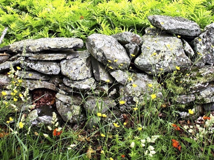
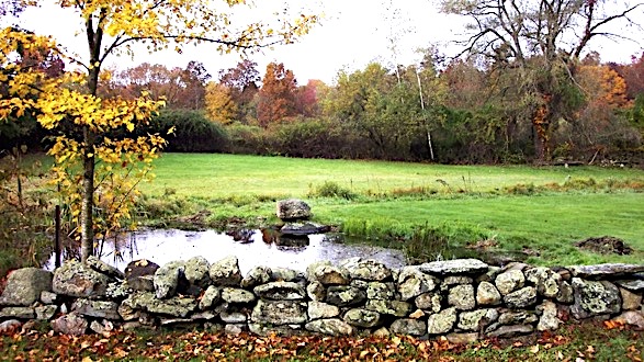
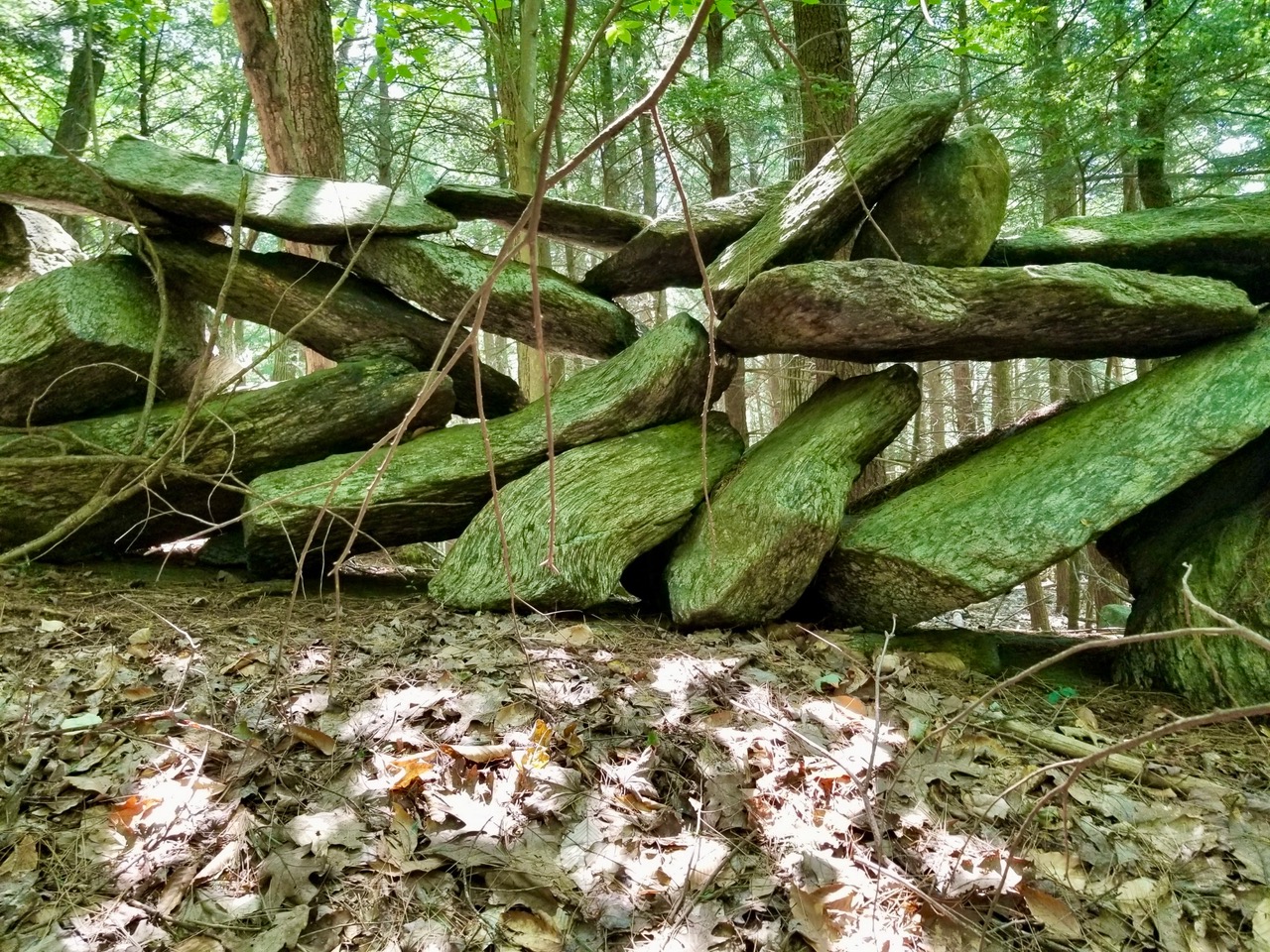
Author: Thorson Robert

“Gray rectangles on the gray hillsides.” An ode to Donald Hall

“The Veteran and a New Field,” by Winslow Homer (1865), selected from the Metropolitan Museum of Art as the cover Illustration for Donald Hall’s memoir “Life Work” (Beacon Press, 2003). 

Why this mention of Donald Hall on the SWI website?  Because –more than anyone else except Robert Frost — he helped me understand what the rural New England psyche was all about, and why it’s so tightly tied to fieldstone walls.  He did so for me neither in person nor poetry, but in his literary nonfiction.  I treasure my signed copies of his books, and my memory of when he signed them.  I write this post on the occasion of his very  recent death on June 23, 2018 at the age of 89, the end of a flesh-and-blood life summarized by his obituary in the New York Times.

Why this image of a flat, stone-free, warm, highly productive field?  Because it’s everything that Hall’s outdoor prose was not,  offering a well-deserved rest from the hilly, hardscrabble, colder, and tougher landscape of his actual life, as exemplified by this passage from  Seasons at Eagle Pond, a collection of essays written from his family farmhouse on New Hampshire’s  Grafton Turnpike, and published in 1987 by Houghton Mifflin.

And although we may regret the darkening day, the beauty of late autumn is real and serious. With the leaves down, granite emerges from the hills, and everywhere we see again the hill’s true shape and the stonewalls that the ancestors built—to enclose their animals and to clear their fields of rocks—making gray rectangles on the gray hillsides.

My introduction to Donald Hall was through another small book of collected essays —Here at Eagle Pond–wand published in 1990 by Houghton Mifflin.  It’s penultimate essay, titled “My New England,” helped bond me to New England, having arrived six years earlier as an alienated immigrant from Alaska who arrived married a woman from Maine.  His essay gave me the cultural identity I was seeking beneath the plasticized exit-ramp culture of our lives.   On page 189 he wrote:

Even today, the culture of the North Country derives from people who moved inland from coastal cities to wilderness late in the eighteenth century. The veterans and families who headed for the lonely north selected themselves to work harder than their brothers and sisters, with less comfort, in return or independence.  Six Keniston brothers fought in the Revolution, one of them my great-grandfather Ben’s grandfather.  They grew up outside Boston and after the war scattered north along with thousands of their fellow veterans to the woodlands of new Hampshire and Maine and what would become Vermont.

Paul Fenton’s ox-cart man brought the dream of liberty north after the Revolution. This independence was not so much the abstraction of the Declaration – lofty, glorious, and Frenchified – as it was a dream  whereby the single unit of a family could exist in benign anarchy without regulation or cooperation.  The liberty boys wanted each man his own nation, little city-states in the hills, small valleys dividing narrow units separated from each other by granite.

Separateness from others was not a price to pay but a reward to win. Settlers built rudimentary houses while they cleared ancient trees and moved rocks, making stonewalls.  Because each family settlement required about forty acres for survival, they could not be crowded. They would never acquire one or save it, but they would contrive their own comfort.  The natural world provided wood for warmth and ice for chilling; add a great garden, with a root cellar for storing apples, potatoes, squash, cabbage, carrots, turnips; add one cow; add deer and turkey shot in the wild, sheep for shearing, maybe flax grown to make linen, bees and sugarbush for sweetness.  In this society, men worked in woods and fields while women labored inside at ten thousand tasks.  Notions of self-sufficiency became a brief reality—which still creates New England character, in the endurance of its superannuated dream.

This works for me. Someone who understands the ionic-strength cultural bond between New England’s stone walls and its regional identity.  Or, as I once wrote: “The soul of New England perches on a rock.”

“Atlas Obscura” on New England’s Stone Walls

“Stone wall, with moss, Putney, Vermont,” by Anna Kusmer.

Earlier this spring, Anna Kusmer, working on an AAAS (American Association for the Advance of Science) science writing fellowship, interviewed me for a story about New England’s fieldstone walls for the internationally popular website Atlas Obscura.  Their “mission is to inspire wonder and curiosity about the incredible world we all share.”  Her piece, titled New England is Crisscrossed with Thousands of Miles of Stone Wallsnicely summarizes the continuing fascination we have for these old walls, and the work of the Stone Wall Initiative in helping to appreciate and conserve them.   To help share her work, I reproduce her lead image.

Highlights from “Northern Woodlands” Magazine

Drawing by Adelaide Tyrol for Northern Woodlands Magazine, March 18, 2018.


On two recent occasions, I was interviewed by Joe Rankin for two articles on stone walls for Northeast Woodlands magazine.  The first was about the creatures inhabiting stone walls.   The second was a Q&A on curious facts about stone walls. Below are a few key illustrations with detailed captions. I found both articles very interesting and nicely done.  The links are embedded in the descriptions above.

Below are two photos with captions that I sent (and they edited) for the second article. I share them here because they show a  remarkable contrast between two of New England’s “wild walls” (not mason-built or maintained), and help illustrate how the precise technical (but not esoteric) language of my classification (Exploring Stone Walls, Walker, 2005) can help us understand the phenomenon more richly.

“Robert Thorson’s teaching wall in Storrs, Connecticut. This is the archetype wall for the crystalline metamorphic terrain of southern New England: a classic farmstead wall consisting of a single, un-coursed tier of stacked two-handers.” 
“This remnant of single wall construction in Lyme, New Hampshire, shows a variety of features: Shapes are blocks, slabs, and pillows; sizes are mainly two-handers, with one one-hander; order is stacked, rather than laid or tossed; structure is a single-tiered, un-coursed wall one-on-two-and-two-on-one, with one error; lithology is mainly granite and gneiss.”

A Few Interesting Facts

On two recent occasions, I was interviewed by Joe Rankin for two articles on stone walls for Northeast Woodlands magazine.  The first was about the creatures inhabiting stone walls.   The second was a Q&A on curious facts about stone walls.  In preparation for the second interview, I jotted down a few points for discussion, which I share below:

Stone walls are landforms.  In fact, they are signature landforms, defining our region as do the lakes of Minnesota, the caverns of central Appalachia, the canyons of the Southwest, and the volcanoes of the Northwest.  Indeed, we live in the Anthropocene epoch, in which human beings are the dominant agency on the planet.  One of the things we do is move mass from one place to another at a greater average rate than did the glaciers during the ice age, a previous epoch.  The stone walls are the most widespread an ubiquitous indicator of our power.

Stone walls reveal that we are part of nature.  Prior to the age of fossil fuels, the mass moved by muscle power is so monumental, the geographic pattern so widespread, and the style so uniform that we must concede that New England’s stone walls emerged naturally as a consequence of the conversion of forest to farm.  Above this “natural” expression of agroecology is the cultural gloss.  Thus, walls are more analogous to the dam’s of beavers than to the fortress walls of castles.  They are “artifacts” arising from an ecological imperative.

At the peak, there were about 250,000 miles of stone wall in New England, based on historic inventories by Robert Thorson (Stone by Stone) and on statistical predictions based on LiDAR mapping in southern New England by a team from the University of Connecticut [1].

The average height of a stone wall is indeed “thigh high,” as Thorson claimed based on the anecdotal evidence of thousands of walls.  This average wall was confirmed by Johnson and Ouimet’s statistical analysis to be 0.76 ± 0.23 m high and 0.96 ± 0.50 m wide.

Prior to the Gilded Age (of outside money), most walls were built on farms one segment at a time by people from those farms and with resources coming from those farms.  During and after the Gilded Age, many of the original walls were built (upgraded) as capital improvements by expert laborers (masons) paid for with money coming from urban and industrial wealth.

The oldest documented stone wall in New England was built in 1607 by English residents of a “Virginia” colony at Sagadahoc, Maine, now known as Popham Point, located at the mouth of the Kennebec River, Maine.  A letter describing that site from the 1620s described “Rootes and Garden Hearbes and some old Walls” left behind after that one-year attempt at colonization failed [2].


Footnote 1. “Physical properties and spatial controls of stone walls in the northeastern USA: Implications for Anthropocene studies of 17th to early 20th century agriculture,” Katharine M.JohnsonWilliam B.Ouimet, Anthropocene 15: Sep 2016, 22-28). https://doi.org/10.1016/j.ancene.2016.07.001)

Footnote 2.  This quote is from Thorson, Stone by Stone (New York: Walker & Co., p. 77), adapted from historian Howard Russell’s The Long Deep Furrow (Hanover, NH: University Press of New England, 1976, p. 9).


Photo:  Lace wall in Chilmark, Martha’s Vineyard, MA.

Square Frame of Stone – Curved Field of Grass

“Ralph Wheelock’s Farm.”  Francis Alexander (American, 1800-1880), c. 1822, oil on canvas, 122  x 64 cm. National Gallery of Art.  Gift of Edgar William and Berenice Chrysler Garbisch, 1965.

A picture is worth a thousand words.  Sometimes, this time-worn cliche is astonishingly accurate. as with my re-discovery of this painting this spring.  Having been invited to Yale University’s  Agrarian Studies Program to discuss my latest book (The Boatman, Harvard Press, 2017), and wanting to know  more about the program, I googled it, and this is the image that popped up. This large oil painting captures the totality –point by point– of my summary description of New England’s lodgment till landscape published in my book Stone by Stone: The Magnificent History in New England’s Stone Walls (Walker/Bloomsbury, 2002):

“Lodgment till is almost singlehandedly responsible for rural New England’s bucolic image–gracefully curved hillside pastures framed by stone walls.”

I was so stunned by the match between this painting and my text  that I immediately began to write this post, which asked if some reader “out there” could provenance the painting.  Paul Barnett responded, and I thank him for that.  When acquired by its first known owner, Colonel Garbisch, the painting was originally named “Dennison Hall, Surbridge, MA.” Subsequent research revealed that there was no such place, but there was a Dennison Hill in nearby Southbridge, MA that looked like the painting, complete with a white house built in 1765 by captain Ralph Wheelock.  Hence the painting was twice retitled, first to “Dennison Hill, Southbridge” and then to “Ralph Wheelock’s Farm,” based on information published in “American Native Painting” by the National Gallery of Art based on research by Arthur Kingston Wheelock, dated June 2000.

So, when viewing the photo at the National Gallery of Art (linked here), I ask that you contemplate the match between the picture and the ~1000-word text.


Travels in New England and New York (1815) by the Reverend Timothy Dwight is arguably the most widely read and appreciated overview of New England scenery during the years of the new republic.  Here’s what Dwight –the widely traveled president of Yale College– had this to say about the soils beneath the fertile uplands of his southern New England landscape.

The hills of this country and of New England at large, are perfectly suited to the production of grass. They are moist to their summits. Water is everywhere found on them at a less depth than in the valleys or on the plains. I attribute the peculiar moisture of these grounds to the stratum lying immediately under the soil, which throughout a great part of this country is what is here called the hardpan.

His summary links the words: hill, grass, moist, stratum, soil, and finally, hardpan.  Reordering these words as narrative, we get: hill, stratum, hardpan, summitssoil, moist, and grass. Here’s my geological explanation of Rev. Timothy Dwight’s summary.

During the last glaciation, the hills of southern New England were high enough to be fairly resistant to glacial erosion. This led to the preservation of an older stratum of hardpan (technically, a lodgment till) beneath the broad summits. Though stones are present, this material easily disaggregates to create a highly fertile, loamy mineral soil, yet remains moist because it is impervious to rain and snowmelt percolating downward. The combination of high fertility and high moisture is perfect for the production of grass, New England’s historically most important crop, whether grazed a pasture and cut for hay. For this reason, the hilltops were sought after, their stones easily moved downhill and stacked into walls.

Now here’s the longer quote from Stone by Stone explaining why this material was so sought-after.

Lodgment till was a gift to the pioneers, with or without the stones. It provided a physical barrier that blocked the seepage into the earth of rainfall and snowmelt. This kept the soils moist, gave rise to perennial springs, and trapped the water in small ponds needed to water livestock. Agricultural soils developed on lodgment till were highly fertile because they were composed of microscopic pieces of glacially pulverized minerals that provided an enormous surface area for biological reactions in the soil, especially those that feed nutrients to plant roots. Lodgment till also produced a terrain of smoothly rolling hills that were usually steep enough to let the water drain away, yet gentle enough to prevent surface gullying. Rock hard beneath the surface, lodgment till was strong enough to support the largest barns. Finally, the gently rolling till-covered landscapes allowed easy movement of humans and their creatures because there was little need to build bridges or avoid rock crags.

In short, my summary reads:   “Lodgment till is almost singlehandedly responsible for rural New England’s bucolic image–gracefully curved hillside pastures framed by stone walls.”  This is the material that lies beneath the canvas of Francis Alexander’s 1822 painting Ralph Wheelock’s Farm, and beneath the New England psyche as well.

Perhaps that is why this painting was chosen by Yale’s Agrarian Studies shows for its home page.


Landscape Design with Stone Walls

It’s nice to know that stone walls are increasingly being retained within subdivision designs, rather than obliterated as being in the way.  In this quick post, I relay (with permission) a particularly eloquent paragraph by Randall Arendt, from a chapter titled “Protecting Natural and Historic Resources through Conservation Design” within his 2009 book Envisioning Better Communities.  I have boldfaced words and phrases that are particularly critical to the mission of the Stone Wall Initiative.

A wide variety of site features involve historical uses, including farmhouses, barns, country lanes, stone walls, wells, cellarholes, hedgerows, etc. Incorporating them into site design can add significant interest value to the neighborhood, improving marketing possibilities and enhancing the quality of life of residents in the development and the surrounding community. From long experience, I can say that designing around stone walls and hedgerows (or fencerows) is not difficult to do when one is given flexibility in lot size, lot width, and street geometry. All too often these features are blithely ignored by site planners who either have not walked the property to locate them, or who demonstrate no care or reverence for these artifacts from earlier eras. (Quoting Daniel Webster: “The man who feels no sentiment or veneration for the memory of his forefathers is himself unworthy of kindred regard or remembrance.”) To the extent that these value-adding aspects of the property are not retained, when it is relatively easy to do so, site designers are not serving either their clients or the community very well…

The pair of his drawings above show: to the left, a subdivision layout conserving and highlighting the historic features; and to the right, a traditional layout where lot size is maximized at the expense of the historic landscape.  Which would you rather live in?

For more information, visit Arendt’s website Greener Prospects.

Saving Historic Mill Walls

The SWI extends its congratulations to the Historical Society of Glastonbury, CT for raising funds to save and restore the stone walls of Hopewell Mills, located on Roaring Brook.  For the full story, consult the July 6 story in the Hartford Courant.

Such mills are testimony to the adaptability and innovation of America’s energy use.  Fully ten percent of America’s energy now comes from renewables, ethanol are on the wane, nuclear is being re-thought, fossil fuels are slowly being phased out, and hydropower has fallen into the shadows.  Building them required stone, and lots of it. Hence, stone walls played an critical role in America’s energy policy, especially in the decades prior to the Civil War.

However, there was a time in American history when hydropower was king, and when manufacturing was totally dependent on it.  Largest was in Lowell, Massachusetts where “the controlled flow of water turned 31 mills, 6,300 looms, and 225,000 thread spindles” in a city created at a hydropower site on the Merrimack River.*  Even there, in the rush to embrace coal, those plants turned to steam and let the water go by.  Eventually most of these mills closed as America’s energy policy moved towards coal, and then petroleum, and now gas.

Such mills nucleated communities all across America, concentrating people, especially recent immigrant workers, in ways that would not be repeated again.


*Quote from my recent book, The Boatman (Cambridge, MA: Harvard Press, 2014), 214. This sources Theodore Steinberg’s Nature Incorporated: Industrialization and the Waters of New England (New York: Cambridge University Press, 1991).


The photo above is from Maynard, MA.

Town of Goshen Connecticut Conserves its Highway Walls

The town of Goshen, CT has created an model ordinance for the conservation of stone walls along town highways.  Having recognized them as essential “agrarian landmarks,” and a vital part of town scenery, they have passed this regulation.

Link to Regulating Roadside Walls in Goshen, CT.

The town website is

http://www.goshenct.gov/public-works-department/files/stone-wall-removal-permit-process

Their work was done to minimize the loss of stone walls via:

  • Homeowners interested in tearing them down, possibly with the intent to sell the stone
  • Over-reach by road improvements, and
  • Piecemeal removal of stones from scavenging (poaching) by non-owners.

One key definition in the ordinance is that the “highway boundary” is the centerline of the stone wall flanking it. Walls can be removed and changed with a permit.  Another is that the default action is to leave the walls as they are, rather than the default action being to allow individual landowner to do whatever they like with them. This is a fundamental issue of private property rights versus community rights.


Photo:  Not in Goshen.  Roadside stone wall on a town highway in Mansfield, CT is being preserved, even though it is only a historic remnant and logging would be easier without it.  

Stone piles? Agricultural or Something Else?

Cons-GoodwallStoneExeter

I’m frequently asked if a stone pile is associated with Native American tradition, or an artifact of agricultural activity. Having been recently asked this by someone with the administrative responsibility of adjudicating this debate, I thought I’d put it in my SWI blog, and make it available to anyone interested.

First, the presence of Native horticulture turns this binary (Native vs. agricultural) into a tautology.   More simply, a pile can be Native AND agricultural at the same time. Cobble piles in Native farming sites should look like those of Euro-Americans.

Second, the binary of farming vs. Native American  is only one set of explanations that is logically equivalent to the set of other explanations we do know about, which is logically equivalent to the set of explanations wee do not know about. A decision about one pile must be made in the context of these three sets.

This begs the question: “What’s a stone pile?” First, it’s an unconsolidated (loose) concentration (many stones) of clast-supported (stones rest upon one another without being supported by matrix) eminence (positive topographic feature). To me, “pile” connotes a “dumped” degree of order, meaning the mass of stones are not deliberately stacked or arranged in any particular way. This leaves the possibility of surface alteration/decoration/shaping possible without disqualifying it as a pile. Depending on context, a stone pile may be no more than a few stones placed one upon the other. Or it might be a giant heap. I’m not going to define it here because you probably have a good working definition in mind. And that’s good enough for now.

The much easier question ignores these sets of possibilities and deals with one straightforward question: Is this an agricultural pile? If we turn this question into a statement that is relevant, ethical, original, and can which will yield a yes/no result is a hypothesis. By relevant I mean is it worth spending personal or societal effort on it. By ethical, I mean that it does not transcend our community standards of behavior toward one another. By original, I mean it hasn’t been done before: each new pile is an original question. By a yes/no result I mean it is one or the other. Anything fuzzier result disqualifies the statement as being a hypothesis.

Depending on circumstances, the question “Is it an agricultural pile” can be tested within certain limitations in the New England woodlands.


UTILITY AND EXPEDIENCE

 The most important and useful limitation is the assumption of “utility and expedience” in the context of making a living from the land with Euro-American agriculture practices involving mixed husbandry: pasture/ tillage/ sugar-bush/ woodlot etc. during what I call the “pioneering” and “established farm stage.” Humans have limited agro-ecological resources and do not do things like building piles either frivolously or “just for the heck of it,” which I call the idiosyncratic function.

Making the utility-expedience assumption requires that stones were piled to dispose of a local excess of stone, and that local excess was not needed to serve as a source of stone elsewhere. If this were the case, and if the stones were uniformly distributed, then so too should be the piles. Furthermore, the spacing and mass of the piles should correlate with the stoniness of the land.

Outcrops, slabs of rock, residual stumps, ravines, swamps, fence-lines, are sites where neither pasture grass nor crops can grow. Hence, they are preempted from productive activity. They will absorb waste stone if they are close enough to the source. In fact, sprawling stone piles on slabs of rock and outcrops are diagnostic of agricultural waste disposal, and will be used before piles are built on non-preempted land.

Utility-expedience requires that the stone in a pile is not carefully places. It can be placed to economize space, but will not carefully so.

Piles grow outward like talus cones. Along any ray, they are concentric. Any variation in the stone coming at the pile will manifest as “vertical” stratigraphy. A dumped load(s) is suggested by a more massive texture (with exceptions). Dumping, however, usually imparts an asymmetry in plan (like a fan) and cross-section (like a snow-drift with the steep side nearest the site of dumping).


COMPARING PILES

An independent test involves comparing the spatial pattern and morphology of known agricultural piles to those of unknowns. The simplest association here is that waste piles are usually plural, and seldom singular. Let’s not forget that waste piles were harvested to create stone walls. Hence, it’s hard to assume that the resulting pattern is the whole original pattern.


OCCAM’S RAZOR

When presented with two explanations for one phenomenon, the most likely to be correct (not the same as being correct) explanation is the simplest one. What this means is that a stone pile in the woodlands can be assumed to be an agricultural pile unless proven otherwise, because this is the simplest explanation.


Learn How to Build Stone Walls

Programs_Prescott_windmill-wednesdays_web_by_Kathy-Wall
Stone Wall Workshop
Saturday, May 21st, 9:30 am-12:30 pm, Adults $40
 
Prescott Farm, 2009 West Main Road, Middletown, RI, 02842
 
Master instructors Chris and Dan Smith have helped students build and repair miles of traditional stone walls in this popular workshop. Great for owners of historic properties in New England who have stone walls on their land, or for anyone interested in the history and craft of stone walls. Advance reservations required. 


Feel free to get in touch for any thoughts or questions: 401-954-0361